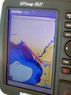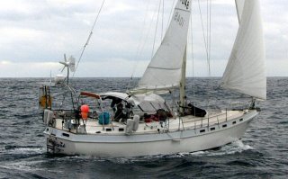
Vagari’s GPS’s map view of our 10-mile trip From La Cruz Huanacaxtle (waypoint 044) to the Puerto Vallarta Harbor entrance. Looks like we are spending the day at the beach when in fact we are at the junction of the deep blue and lighter blue (Vagari is represented by the black triangle on the route line). How can that be? GPS’s are accurate to 30 feet; I have found that usually the error is less than 15 feet. The answer of course is that the charts are wrong. The charts are based on surveys made in the 1870’s. They contain lots of notes that make statements like “ this island has been reported to be 3 miles West of the position shown”. Or my favorite, “exposed rock reported in this area in 1910, position unknown”.
To make it more interesting, there is a river close to the entrance to Puerto Vallarta Harbor that doesn’t show but sends a lot of silt into the bay. So the water is very shallow around this river and out into the bay for almost a mile. This river runs next to the P.V. airport, which is right on the coast but doesn’t show on the chart either. After all it was almost certainly built after the 1870’s.
When cruising in the States I felt that GPS eliminated any navigation challenge. In Mexico you still need to be an accurate, alert and conservative navigator.
To deal with these issues cruisers have written books that give accurate GPS positions and commentary about the shortcoming of the charts in a particular place. Cruisers also give advice to those who ask. A seven-year vet of cruising Mexico drew us a great chart of the anchorages at Isla Isabela on the back of a place mat. I will keep it as long as we cruise.
Waypoint 047 is ½ kt. mi. off the entrance to the Paradise Village Marina.


No comments:
Post a Comment